Water is our most sacred resource, according to Emily Constantine Mercurio, CEO and cofounder of CivicMapper. Leading the Pittsburgh-based technology firm into its fifth year, she and her team put geospatial data to work helping cities better prepare for the future: by improving water and sewer infrastructure and solving mobility problems.
Emily Constantine Mercurio, PhD, PG, launched her career in geology by studying Iceland’s ice-bound volcanoes, Mexico’s volcanic ash, and New Zealand’s natural hazards, proving that “a girl from Jeannette, PA, can go places.” She studied satellite images for NASA and completed geologic research and development projects with Michigan Tech and the Rochester Institute of Technology. Oftentimes, along her journey, Mercurio found that she was the only woman, either in the office or out in the field, in this heavily male-dominated profession. But that only motivated her to work twice as hard as her colleagues.
She returned to Western PA as a mother of two young children to complete her PhD at the University of Pittsburgh, where she taught earth science courses. Later, inspired by her commitment to protecting water, she joined Cabot Oil & Gas, where she’s credited with ensuring the installation of deeper natural gas well casings, making hydraulic fracturing safer across Pennsylvania, and for helping to establish the company’s first GIS (Geographic Information System) Department.
She launched CivicMapper in 2015 with her husband, Matt Mercurio, GTO (Geospatial Technology Officer), and friend, Christian Gass, VP and COO, because, as she puts it, “I’ve always wanted to have a company of my own to make maps in the most innovative way possible.” She graciously welcomed me to her office, just around the corner from BlastPoint’s HQ, earlier this year, to chat stormwater, public transit, and data. Our conversation, below, has been edited and condensed for clarity.
What kind of work does CivicMapper focus on?
We’re very interested in stormwater and wastewater because we believe water is the most important natural resource. Cities need better tools to help people manage water, especially because of climate change, where we’re seeing more frequent and severe rainstorms in the U.S., and we have aging infrastructure.
It’s the perfect storm: more water and less infrastructure to move that water away from where people are living and where they have assets. Better mapping informs better decision-making. So we work with people on the front lines of these issues: stormwater management, infrastructure, and transportation.
Stormwater problems translate not only to flooded homes and roads, but also to landslides, structural damage, and polluted runoff, so it’s an extremely expensive issue for property owners, insurance companies, and governments. Water is unpredictable and more powerful than we are. We need to be better prepared and able to work with water more intelligently, so we can build a more resilient society and adapt to change.
That’s distinctly different from what some other technology companies in the region are doing with geographic data and machine learning, wouldn’t you agree?
Pittsburgh is becoming a center of excellence for technology. It’s amazing. There are so many companies here that use maps or geospatial information in some way. At CivicMapper, this technology itself is our primary focus. Our expertise in this field, and our agile approach to development, really empowers us to create awesome tools for people dealing with climate, infrastructure, and transportation challenges. We think this is what sets us apart from the herd.
It’s part of the small business ethos. We can do our own research and development, test our ideas, and fail and recover. That’s where we always want to be: a step ahead, always innovating. It’s part of our company culture to go for the “moon shot” and create something really special and useful, as quickly as we can. We love open source geospatial data and technologies, and feel that these are inspiring innovation unlike anything we’ve seen in the past 20 years.
Your work on stormwater must present other challenges in this region. Can you talk about those?
Pittsburgh is unique. Within the Allegheny County Sanitary Authority’s (ALCOSAN) service area, we have 83 municipalities. Each has its own municipal engineer. They have their own challenges for collecting data about stormwater and sewer systems. Sometimes they’re combined stormwater and sewer infrastructure, so their pipes carry both at the same time.
That means, when it rains here, you sometimes have too much water for the system to handle, and if you have a combined stormwater and sewer system then you have sewage coming out of the pipes and going into the rivers. That is our challenge. It’s not unique. There are many other cities that have combined sewer and stormwater infrastructure, and share many of the same problems that we do. Combine this with changing regulations and requirements, plus record rainfall, and you have a tough situation.
CivicMapper was working with 3 Rivers Wet Weather, a not-for-profit founded to help municipalities manage their wet weather infrastructure and meet regulatory requirements. They work with ALCOSAN to do that. We partnered with 3 Rivers Wet Weather to take sewer data from all 83 municipalities and put it on one, uniform map. The borough engineers collect the data, we obtain it from 3 Rivers Wet Weather, and then we condition and stitch it all together into one map.
Our sewer infrastructure connects all of us. It’s like the Internet. It’s connecting to every building and every house. It’s this massive network that’s so impressive and is a true feat of engineering.
Emily Constantine Mercurio, CEO, Co-founder, CivicMapper
Every pipe is named, we know the material that every pipe is made of, its diameter, and which direction the water and waste are flowing in the pipe. And then we connect it all into one data set. There are manholes, outfalls, inlets—all of these features have to be mapped, and we’re still mapping it and making improvements to the map based on new data coming in.
There’s a lot of data management and editing that goes into it. The reason for making this unified map is so that everyone can have access to the same data: operators, municipal managers, maintenance workers. It’s important to have everyone on the same page. And one bonus result of having this map of the sewer network is that we can create things like the Flush-It app.
Please, talk about the Flush-It app!
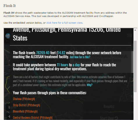
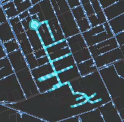
This was a collaborative effort with ALCOSAN, 3 Rivers Wet Weather, and us. You type in your address and see where your waste is going, how long it takes to get to the treatment facility, and how far it has traveled.

The beauty is that you’re learning about the infrastructure beneath your feet that you don’t even see. It’s a great outreach tool to let people know about the system that’s taking waste away from your house to ALCOSAN’s treatment facility before it is reused, recycled, or discharged back into the environment. A single flush takes on a life of its own after it leaves your house.
It’s really eye-opening to see how many communities a flush passes through.
We think every city should have a Flush-It. Because we did it in Pittsburgh, which is probably the hardest place to do it since we have 83 municipalities and 83 unique datasets to stitch together. We have proven we can do it for any city, as long as they have the data to base it off of. But even if they don’t have the data, we can help with that also. We have lots of expertise in new data acquisitions and data development.
CivicMapper works in the mobility space, too?
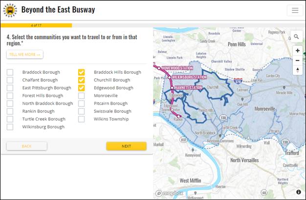
We worked with Pittsburghers for Public Transit (PPT) to create the Beyond the Busway app. PPT is a great organization with great, forward-thinking leadership. They wanted to gather feedback from people in the eastern suburbs who rely on public transportation so they could better understand how those residents were getting to wherever they needed to go.
Over the past decade, Port Authority has reduced bus routes to those eastern suburbs. PPT wanted to create a tool so they could go out and gather feedback from the people affected by these cuts, and ask “Where do you need to go? What do you use public transit for?” They wanted to have this survey informed by a map so that people could say, “I go here, this is how I need to get there, and this is how I want to use transit.”

There wasn’t anything on the market that did exactly what they wanted, so we created this hybrid web application no one had ever seen before. It’s a questionnaire, and as the survey taker is asking questions, the subject’s answer informs the map on the other side of the screen.
The advantage of having the map is that it helps the respondents visualize their current route and how a potential “new” route might be better. The maps generated form the survey and the responses to the answered questions were collected through the application and shared to the project team and other stakeholders, including the Port Authority.
We want to use this hybrid map-survey tool for other projects. It can be used to gather feedback on any type of question where place and location are important.
Find out about BlastPoint for nonprofits.
Are you doing any work in infrastructure redesign to prepare for self-driving cars?
We are very interested in using data from autonomous vehicle systems and mobile mapping technologies to characterize the stormwater infrastructure in cities. We want to use derivative data from the images and information being collected from these mapping systems. Curbs, storm drains, curb inlets, all of these features are stormwater infrastructure.
We want to know the dimensions of those things so we can use them in more detailed urban hydrologic analyses, along with real time environmental sensor data. We’re currently creating technologies to use these types of data to model where and how much water moves across the landscape.
Overall, we want to connect people to environmental and infrastructure data in a way that supports better and more data-driven decision making in the face of climate, pollution, and a rapidly evolving society.
At CivicMapper, we leverage geospatial data and technologies to provide new insights that people might not have known before. I have seen the benefits of geospatial technology over and over again, and I know it can make such a great impact and improve how we live. We always want to be a contributor to these success stories.
Visit www.civicmapper.com for more information.
Related Links:
The Flush It interactive tracing tool
Brian O’Neill’s coverage of CivicMapper and the Flush It app in in the PGH Post Gazette
Emily Mercurio on the Going Deep with Aaron Podcast
Pittsburghers for Public Transit


